-

- 220
Here is the one I use for NY, after it loads hit the BB button then full image to make it bigger.
http://sirocco.accuweather.com/sat_m...rs/isarNY_.gif
Posted from my CrackBerry at wapforums.crackberry.com05-28-09 02:27 PMLike 0 -
- 220
One more for NY
http://images.intellicast.com/WxImag..._None_anim.gif
Posted from my CrackBerry at wapforums.crackberry.com05-28-09 02:31 PMLike 0 -
- 1
-
- 1,582
ooh, i like that one too..i may add a shortcut for that one too. what are the steps to find the url for my city (houston)One more for NY
http://images.intellicast.com/WxImag..._None_anim.gif
Posted from my CrackBerry at wapforums.crackberry.com05-28-09 05:30 PMLike 0 -
- 77
http://www.accuweather.com/m/US/wigs...64&anim=1&af=5
This what I use. Works great and its animated! I also resized it to 360x480 so it looks perfect in portrait.
Posted from my CrackBerry at wapforums.crackberry.com05-28-09 09:04 PMLike 0 -
- 77
Also one more. I like this one to its more detail if you get click full image but sometimes its hard to read cause it picks up any precipitation like fog or anything.
http://radar.weather.gov/ridge/lite/N0R/GSP_loop.gif
Posted from my CrackBerry at wapforums.crackberry.com05-28-09 09:07 PMLike 0 -
- 5,415
-
- 200
Thank you very much for this idea. I haven't found a weather app that meets my needs yet, until this.
I went a bit further and set up all the animated maps for radar, satellite, cloud cover etc on my QL and it works great.
So great, that I trashed WeatherBug. But wait a minute, WB gave me severe weather alerts!
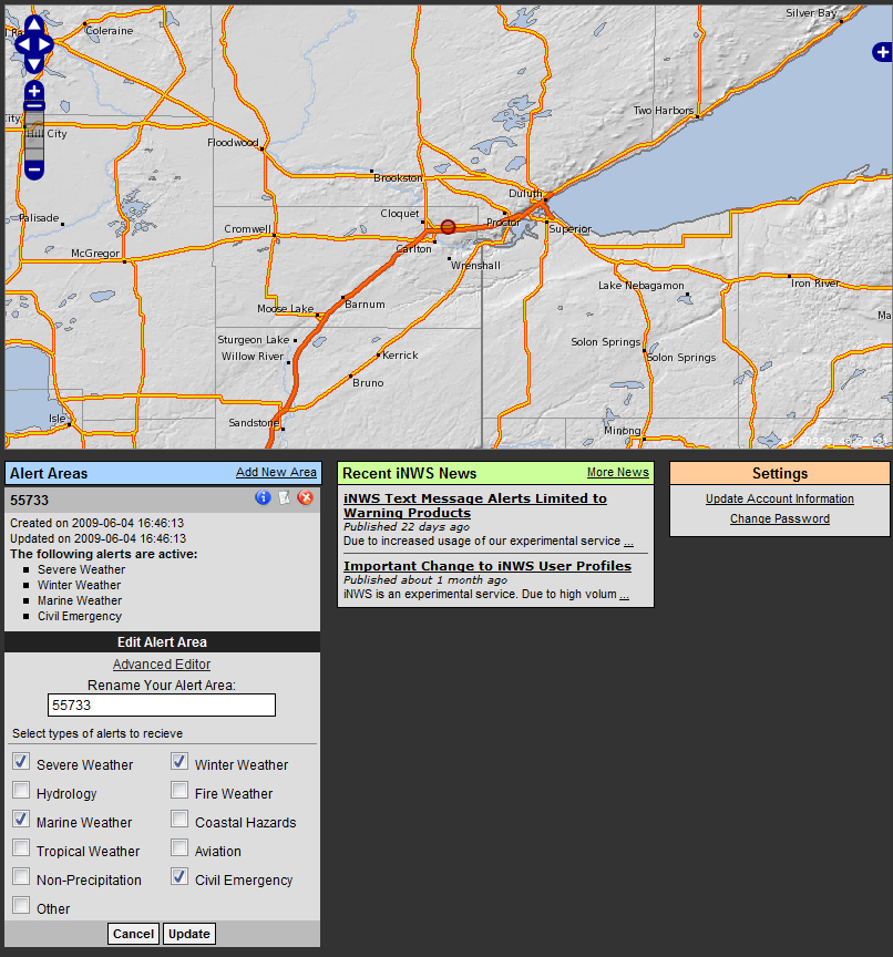
I went searching for something to do this and this is what I came across: Welcome to interactiveNWS
This website allows you to configure alerts for a variety of locations, which options for each location that are emailed to you or sent via SMS.
Screenshot:
 06-04-09 12:05 PMLike 0
 -
- 20
-
- 135
You stole my idea and expounded upon it!!! JK, I had two shortcuts similar to this with NWS, but I just had the main page summary and the accuweather radar map...
Your setup is a lot more "eye-pleasing"!06-05-09 12:35 AMLike 0 -
- 77
Lol Yea its ben raining like crazy here all day. Lord knows we need it though. Did you have any problem getting your local radar to show up? And I guess the resizing thing worked? I guess I didn't go into much detail. Let me know if you need any help.
Posted from my CrackBerry at wapforums.crackberry.com06-05-09 01:41 AMLike 0 -
- 180
I couldn't figure out how to get to that radar thru the accuweather site, or how you resized the radar, so what I ended up doing was simply changing the URL info to apply to Dallas rather than SC....changed city & state in the url, along with longitude & latitude....also altered the zoom (miles) on a couple of the radars....turned out pretty nice....Lol Yea its ben raining like crazy here all day. Lord knows we need it though. Did you have any problem getting your local radar to show up? And I guess the resizing thing worked? I guess I didn't go into much detail. Let me know if you need any help.
Posted from my CrackBerry at wapforums.crackberry.com
haven't found a 5 day forecast page that I like yet.....06-05-09 01:13 PMLike 0 -
- 200
Here's some info I found yesterday on how to format the URL.
There is a URL that points to an image file that is updated in realtime. If you set some parameters of the URL to be a variable, then you can populate those variables using the location you want the radar for. The image URL can be manipulated to change the city, state, image size, animation (0, 1). You will also have to have some way to look up the approximate latitude and longitude of the city/state, as it uses the latitude and longitude to look up the image. For example, the following would be the link to view the Humble, TX radar to fit perfectly in PORTRAIT MODE:
For anim=, set it to 0 for current radar, set it to 1 for animated radarCode:http://www.accuweather.com/m/US/wigs.axd?city=HUMBLE&state=TX&w=360&h=480&type=_SIR&geoWidth=200&lat=29.99&lon=-95.18&anim=0&af=5
For af=, set it any value. A value of 5 animates the image to show the last 5 images.
So, the URL above will be for portrait version. When the phone switches to landscape mode, the image would have to be refreshed with an updated w= and h= value. For landscape mode, update the values from w=360&h=480 to w=480&h=360...Now it will show perfectly in landscape.Last edited by jhendrickson; 06-05-09 at 01:37 PM.
06-05-09 01:34 PMLike 0 -
- 77
It looks like they may have changed there radar images. I just went to accuweather and I can't get the same radar image either. Good call on just changing the url though. Glad everything worked out. Also thanks for the info about the code. I changed it to show the last 10 images to get a better view of the path of the storms. And I guess it would be nice to have it look perfect in either portrait or landscape. My try to see which one looks better.
Posted from my CrackBerry at wapforums.crackberry.com06-05-09 02:19 PMLike 0 -
- 1,515
I ran into same issue, did same as you and just edited the URL. Great looking map, resizing it makes it even more practical. Thanks stoner99 for posting your URL.I couldn't figure out how to get to that radar thru the accuweather site, or how you resized the radar, so what I ended up doing was simply changing the URL info to apply to Dallas rather than SC....changed city & state in the url, along with longitude & latitude....also altered the zoom (miles) on a couple of the radars....turned out pretty nice....
haven't found a 5 day forecast page that I like yet.....06-05-09 02:20 PMLike 0 -
- 200
I came across a bunch more images that some of you may find useful. I'm still hunting for more animated radar/satellite/IR imagery urls that we can use with QL. Until then...
Weather Underground
Satellite http://maps.wunderground.com/data/images/us_ir.gif
Radar http://maps.wunderground.com/data/640x480/us_rd.gif
Visible Satellite http://maps.wunderground.com/data/640x480/us_vi.gif
Fronts http://maps.wunderground.com/data/images/us_sf.gif
Temperature http://maps.wunderground.com/data/640x480/us_st.gif
Jet Stream http://maps.wunderground.com/data/images/us_jt.gif
Humidity http://maps.wunderground.com/data/images/us_rh.gif
Dew Point http://maps.wunderground.com/data/640x480/us_dp.gif
Heat Index http://maps.wunderground.com/data/640x480/us_hi.gif
Wind http://maps.wunderground.com/data/640x480/us_ws.gif
Wind Chill http://maps.wunderground.com/data/640x480/us_wc.gif
UV Forecast http://maps.wunderground.com/data/images/us_uv.gif
Air Quality http://maps.wunderground.com/data/images/us_ozone.gif
Visibility http://maps.wunderground.com/data/640x480/us_vs.gif
Snow Depth http://maps.wunderground.com/data/640x480/us_snow.gif
NOAA National
Satelite http://www.nws.noaa.gov/satellite_images/national.jpg
Radar http://radar.weather.gov/ridge/Conus/Radar...atest_Small.gif
National Forecast http://www.weather.gov/forecasts/national_forecast.jpg
Graphical Forecast http://www.weather.gov/forecasts/graphical...MaxT1_conus.png
Tempature http://www.weather.gov/forecasts/graphical...us/T2_conus.png
Wind & Wind Speed http://www.weather.gov/forecasts/graphical...dSpd2_conus.png
Chance of Precipitation http://www.weather.gov/forecasts/graphical...oP121_conus.png
Precipitation Amount http://www.weather.gov/forecasts/graphical.../QPF1_conus.png
Weather Type http://www.weather.gov/forecasts/graphical...s/Wx2_conus.png
Sky Cover http://www.weather.gov/forecasts/graphical.../Sky2_conus.png
Severe Weather Warnings http://www.spc.noaa.gov/products/wwa/wwa_new.gif
NOAA Regional
North East http://radar.weather.gov/ridge/Conus.../northeast.gif
Central Great Lakes http://radar.weather.gov/ridge/Conus/Radar...entgrtlakes.gif
Northern Mississippi Valley http://radar.weather.gov/ridge/Conus/Radar...ppermissvly.gif
Northern Rockies http://radar.weather.gov/ridge/Conus/Radar...orthrockies.gif
Pacific Northwest http://radar.weather.gov/ridge/Conus/Radar...acnorthwest.gif
Alaska http://radar.weather.gov/ridge/Conus...Img/alaska.gif
Southeast http://radar.weather.gov/ridge/Conus.../southeast.gif
Southern Mississippi Valley http://radar.weather.gov/ridge/Conus/Radar...outhmissvly.gif
South Plains http://radar.weather.gov/ridge/Conus/Radar...southplains.gif
Southern Rockies http://radar.weather.gov/ridge/Conus/Radar...outhrockies.gif
Pacific Southwest http://radar.weather.gov/ridge/Conus/Radar...acsouthwest.gif
Hawaii http://radar.weather.gov/ridge/Conus...Img/hawaii.gif
Animated:
US Visible Satellite: http://maps.wunderground.com/data/64...us_vi_anim.gif
US Satellite: http://maps.wunderground.com/data/64...us_ir_anim.gif
US Fronts: http://maps.wunderground.com/data/64...us_sf_anim.gif
US Jet Stream: http://maps.wunderground.com/data/images/us_jt_anim.gif
US UV Forecast: http://maps.wunderground.com/data/images/us_uv_anim.gif
US Air Quality: http://maps.wunderground.com/data/im...ozone_anim.gif
US Humidity: http://maps.wunderground.com/data/images/us_rh_anim.gif
US Radar: http://maps.wunderground.com/data/64...us_rd_anim.gif
US Dew Point: http://maps.wunderground.com/data/64...us_dp_anim.gif
US Temperature: http://maps.wunderground.com/data/64...us_st_anim.gif
US Heat Indix: http://maps.wunderground.com/data/64...us_hi_anim.gif
US Wind Chill: http://maps.wunderground.com/data/64...us_wc_anim.gif
US Wind: http://maps.wunderground.com/data/64...us_ws_anim.gif
US Visibility: http://maps.wunderground.com/data/64...us_vs_anim.gif
US Snow Depth: http://maps.wunderground.com/data/64..._snow_anim.gif
Current and Alerts
Current Weather: http://image.weather.com/images/maps/curre...rwx_600x405.jpg
Current Temperatures: http://image.weather.com/images/maps/curre...emp_600x405.jpg
Temperature Change: http://image.weather.com/images/maps/speci...chg_600x405.jpg
Frost and Freeze Advisories: http://image.weather.com/images/maps/winte...ost_600x405.jpg
Lightening Strikes: http://image.weather.com/images/maps/sever...nus_600x405.jpg
Sever Weather Alerts: http://image.weather.com/images/maps/speci..._us_600x405.jpg
Sever Watches: http://image.weather.com/images/maps/speci...ch1_600x405.jpg
Earthquake Reports: http://image.weather.com/images/maps/speci...rth_720x486.jpg
National Doppler Radar: http://image.weather.com/web/radar/u..._plus_usen.jpg
Atlantic Ocean Satellite: http://image.weather.com/images/sat/...at_720x486.jpg
Gulf of Mexico Satellite: http://image.weather.com/images/sat/...at_720x486.jpg
Snow Quality: http://image.weather.com/images/maps/winte...ual_600x405.jpg
Snow Cover: http://image.weather.com/images/maps/winte...sen_600x405.jpg
Current UV Index: http://image.weather.com/images/maps/healt...map_720x486.jpg
Current Winds and Gusts: http://image.weather.com/images/maps/boat-...cur_600x405.jpg
Current Heat Index: http://image.weather.com/images/maps/curre...eat_600x405.jpg
Storm Track Atlantic: http://image.weather.com/images/maps/pt_BR...ack_720x486.jpg
2004 Atlantic Storm Tracks: http://image.weather.com/images/maps/tropi...op8_720x486.jpg
Sea Surface Temperature and Tropical Cyclone Activity http://maps.wunderground.com/data/images/tropical.gif
Forecasted
Today�s Forecast: http://image.weather.com/web/forecast/us_w...ge_usen_600.jpg
Tonight�s Forecast: http://image.weather.com/web/forecast/us_w...ge_usen_600.jpg
Snowfall Forecast: http://image.weather.com/images/maps/forec...cst_600x405.jpg
Rainy travel: http://image.weather.com/images/maps/trave...ain_720x486.jpg
UV Index Forecast: http://image.weather.com/images/maps/forec...nus_600x405.jpg
Interstate Forecast: http://image.weather.com/images/maps/forec...fcst_600_en.jpg
Fall Foliage: http://image.weather.com/images/maps/speci...cur_720x486.jpg
Cloud Cover Today�s Forecast: http://image.weather.com/images/maps/forec...nus_600x405.jpg
Cloud Cover Tonight�s Forecast: http://image.weather.com/images/maps/forec...nus_600x405.jpg
Cloud Cover Tomorrow�s Forecast: http://image.weather.com/images/maps/forec...nus_600x405.jpg
Radar Estimated Precipitation: http://image.weather.com/web/maps/radar/re...rday_600_en.jpg
Precipitation Forecast: http://image.weather.com/images/maps/forec...cst_600x405.jpg
Forecasted Winds: http://image.weather.com/images/maps/boat-...cst_720x486.jpg
Wind Chill Forecast: http://image.weather.com/images/maps/forec...ill_600x405.jpg
Morning Forecast: http://image.weather.com/images/maps/boat-...cst_720x486.jpg
Midday Forecast: http://image.weather.com/images/maps/forec...cst_600x405.jpg
Evening Forecast: http://image.weather.com/images/maps/forec...cst_600x405.jpg
Schoolday Forecast: http://image.weather.com/images/maps/schoo..._wx_720x486.jpg
Forecast Heat Index: http://image.weather.com/images/maps/forec...ind_600x405.jpg
Thunderstorm Forecast: http://image.weather.com/images/maps/trave...hun_600x405.jpg
History
Hurricane Strike Frequency: http://image.weather.com/images/maps/tropi...req_720x486.jpg
Snow History: http://image.weather.com/images/maps/speci...st1_600x405.jpg
Health
Aches and Pains Index: http://image.weather.com/images/maps/healt...hes_720x486.jpg
Ozone Levels: http://image.weather.com/images/maps/healt...nus_600x405.jpg
Air Quality Forecast: http://image.weather.com/images/maps/healt...day1_600_en.jpg
Respiratory Index: http://image.weather.com/images/maps/healt...esp_720x486.jpg
Tree Pollen: http://image.weather.com/images/maps/healt...pol_720x486.jpg
Grass Pollen: http://image.weather.com/images/maps/healt...pol_720x486.jpg
Weed Pollen: http://image.weather.com/images/maps/healt...pol_720x486.jpg
Mold Spores: http://image.weather.com/images/maps/healt...ore_720x486.jpg
Influenza Reports: http://image.weather.com/images/maps/seaso...nal3_600_en.jpg
Fitness Index: http://image.weather.com/images/maps/healt...nus_600x405.jpg06-05-09 03:05 PMLike 0 -
- 1,582
-
- 2,750
Customise your Radar View
Radar link below fills entire Blackberry screen with Animated local radar.You make some simple changes to link below and such radar can be yours.
-http://www.accuweather.com/m/US/wigs.axd?city=VIRGINIA+BEACH&state=VA&w=320&h=240&type=_SIR&geoWidth=175&lat=36.80&lon=-76.05&anim=3&af=5
Location
Virginia+Beach =City
VA =State
BB Screen size
320 =screen width
240 =screen Height
Zoom in & out of radar view
175 = Lowering number zooms in /Higher number zooms out
Location Coordinates
36.80 =latitude
76.05 =longitude
The above need to be changed in link to your - Location ,BB Screen size and your Location Coordinates.
Coordinate look up
Address Map Coordinate (Longitude/Latitude) Finder
When those changes are made you will have customized local animated radar that fits your BB screen like a glove.
local Radar on my 8330
My favorite surfboarding spots down the coast.
Hatteras Island NC - Rodanthe & Buxton
Last edited by Slingbox; 06-06-09 at 07:16 PM.
06-05-09 08:22 PMLike 0


- Forum
- BlackBerry OS Phone Forums
- BlackBerry OS Apps
*Free* Build your own Weather App *Free*
LINK TO POST COPIED TO CLIPBOARD